Resources
B.C. Groundwater Updates
Edition: Update on Groundwater, December 2024

IN THE DECEMBER 2024 ISSUE:
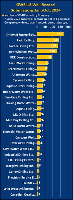
- GWELLS-2024 Review of Well Record Submissions
- WLRS Updates
- Provincial Government Groundwater Program Regional Update
- Provincial Groundwater Observation Well Network (PGOWN) Update
- Registering as a GWELLS user to submit well records online
REPORT NON-COMPLIANCE
- Have you noticed a well that does not meet the construction standards of the Groundwater Protection Regulation?
- Know of someone who is drilling a well or installing a well pump without being registered?

WLRS Updates
30 years of Aquifer Mapping
The Province’s current groundwater program owes a great debt to the BC public service who built and stewarded the Provincial aquifer inventory. This inventory is currently showcased in the GWELLS application which displays information on over 1,200 aquifers. Although the current inventory contains a wealth of information for water management, the information is primarily limited to developed areas and only covers approximately 4% of the spatial area in the Province. As new groundwater information continues to become available through development and research, it is crucial to continue to refine and update the inventory. Likewise expanding the mapping and characterization of aquifers into less developed areas will support planning and design, as development pressures increase through population growth and resource development.
When the Water Sustainability Act came into force in 2016, the Province’s new role in groundwater licensing required that the Provincial aquifer inventory and other groundwater information become more accessible. Development of the GWELLS application in 2018 has been a great success in bringing the Provincial groundwater inventory of wells and aquifers to the public. GWELLS has become a hub for groundwater information which has evolved to bring together aquifer mapping with information from other government groundwater data resources in one interface. Users of GWELLS can quickly access a snapshot of geochemistry, climate, and water levels for aquifers where this data is available as well as links to drilling & operation advisories, observation wells, numerical models, aquifer notations, water budgets and groundwater surface water interactions. Work is ongoing to improve the quality and accessibility of groundwater data through continuous improvement to GWELLS as needs and opportunities arise. In addition to the links and information displayed on the GWELLS aquifer summary page, the aquifer factsheets provide summarized information on well yield, well depth, static water level, and in areas where more aquifer information is available. The factsheets also provide summaries of long-term groundwater level trends, water quality, water budgets, numerical models and aquifer parameters such as transmissivity.
Another Provincial initiative that has been instrumental in documenting groundwater science and research since 2016 is the Water Science Series (WSS) of reports. This publicly accessible and peer-reviewed publication series has provided a venue for documenting and cataloguing new aquifer mapping projects. When searching for a specific aquifer through the GWELLS aquifer tab, people can find a link to the detailed WSS publication which describes the area mapped, methods, cross-sections or models used, data gaps and recommendations.
The analysis methods available for mapping aquifers have evolved considerably since the provincial aquifers were originally mapped in the 1990’s. The quantity and quality of data available within the GWELLS application far exceeds what was available 30 years ago and with the WSA requirements for submission of well records, the data resource will continue to improve. Today, the aquifer mapping process has been facilitated by the availability of high-resolution topographic mapping, automated workflow processes through scripting, and the availability of two- and three-dimensional visualization programs. These improvements are particularly important in areas of complex stratigraphy and pressures on the sustained stewardship of aquifers.
As the Province continues the work of groundwater licensing and management under the WSA, the need for groundwater information will grow. The provincial aquifer inventory will evolve so that water management can be tailored to the unique characteristics and the particular challenges being faced in various communities. Communicating information about aquifers to the public will continue to be a priority as local input will be needed to understand options and navigate offsets.
With the emerging recognition of the importance of urban groundwater as a natural asset which must be understood for infrastructure planning and protected as a water resource, the Province can collaborate with urban municipalities to improve urban groundwater data and plan technical projects that can support policy decisions. Likewise, as the role of hydrostratigraphy in understanding hydrological response to forestry and agricultural land drainage at the watershed scale is becoming recognized, mitigating adverse impacts will require expanded aquifer information in areas that are not presently mapped or characterized. These needs could lead the Province to develop and utilize new data sources such as remotely sensed information, soil mapping, or indirect methods (e.g. thermal mapping). The Province may also seek data sharing agreements with other agencies, municipalities, First Nations or private companies where possible.
The Provincial approach to mapping, inventorying and communicating information about aquifers continues to evolve as the data and tools available improve, and new needs emerge. The aquifer mapping inventory accessible through GWELLS continues to provide the foundation for provincial aquifer information which can form the basis for further study at the site scale or to focus on specific issues. The foresight of the BC public service in building this resource has been invaluable to the people of BC.
3rd Annual BC Groundwater Symposium - December 12th, 2024
WLRS will be hosting the 3rd annual Provincial Groundwater Science Symposium on December 12th, 2024 (9am to 3:45pm). The online symposium will highlight current groundwater research and monitoring projects throughout the province through a series of short presentations. A list of Session topics is provided below.
| 9:00 am | Welcome & Introduction |
| 9:15 am | Session 1: Groundwater Monitoring and Watershed Characterization |
| 10:50 am | Session 2: Provincial Databases Supporting Science and Research |
| 11:40 am | Special Presentation: IAH-CNC’s Advocacy Towards the Integration of Hydrogeology into Freshwater Management in Canada |
| 1:00 pm | Session 3: Mapping, Hydraulic Connections, and Water Budgets |
| 2:35 pm | Session 4: The Interface Between Groundwater and Surface Water |
| 3:40 pm | Closing Remarks |
To request a calendar invite, please email groundwater@gov.bc.ca.
Trends in Groundwater Levels
The Long-term Trends in Groundwater Levels in B.C. webpage is now updated and available here.

THIS REPORT IS PREPARED FOR YOU by the water management teams within the Ministry of Water, Land, and Resource Stewardship (WLRS), and the Ministry of Environment and Climate Change Strategy (ENV)


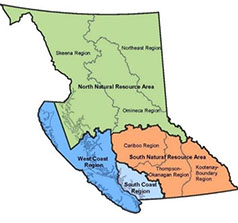
Provincial Groundwater Program Regional Update – North Natural Resource Area
Existing Groundwater Licensing Update
A provincial initiative began in February 2024, all existing use groundwater applications have been centralized and are being put through a streamlined process. This process will be continuing to focus on completing existing use groundwater applications across the province. In the North Area, to date, approximately 90% of the existing use groundwater applications have been processed.
Provincial Groundwater Observation Well Network (PGOWN)
In the Skeena Region, observation well OW089 was decommissioned and a new well (OW520) was drilled, pump tested and commissioned to replace OW089. An unused test well in the city of Terrace now has been adopted by the province and fully incorporated into the observation well network in 2024.
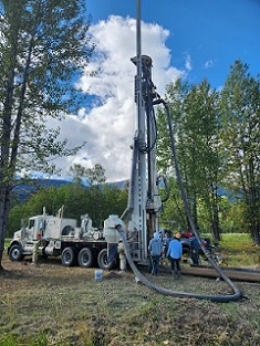
Drilling of OW520 in Smithers (2024, WLRS)
Groundwater Science Studies
The Stoney Creek numerical model project has been successfully completed by University of Northern BC. The project used a calibrated numerical model to assess the impact to groundwater-surface water interactions under different groundwater use scenarios. The final report is expected to be released soon.

Provincial Groundwater Observation Well Network (PGOWN) Update
The PGOWN is happy to announce the completion of two new observation wells in recent months, with a third to be completed later this year. The newly drilled wells are located in Westwold (OW518) and Smithers (OW520). A pumping test was completed at the Smithers location to better understand the hydrogeological properties of the aquifer. A pumping test for the Westwold well should be completed sometime next summer. These wells are to replace existing, ageing PGOWN sites in those areas. In future years, it is likely that many of our drilling projects will focus on replacing our ageing wells, some of which are well past half a century old.
The third well, yet to be drilled, will be located in Comox, in partnership with the K’omoks First Nation, and will monitor groundwater use in a primarily agricultural area.
All newly drilled PGOWN wells will have a well report written by our Groundwater Monitoring Specialists and Regional Hydrogeologists. These reports will be attached to their well records in GWELLS and included in EcoCat (BC Ecological Reports Catalogue).
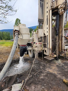
Well development at newly drilled OW520 in Smithers (2024, ENV).

Do you have questions about the PGOWN?
Contact groundwater@gov.bc.ca
Learn more about the Provincial Groundwater Observation Well Network by using the interactive map.

Registering as a GWELLS user to submit well records online
Get access in three easy steps:
1. Visit the GWELLS BCeID registration page to obtain either a Basic BCeID account or Business BCeID account. (Note, if you already have a Basic or Business BCeID account, you do not need to create a new one to access GWELLS)
2. After obtaining your BCeID, go to GWELLS and select the login button (top right of the application screen).
3. Once you have logged in, email gwells@gov.bc.ca to request access for your BCeID user account.
Once access has been granted, you will be able to enter and submit groundwater well reports through GWELLS.

CONTACT US
For general inquiries or the contact information for groundwater staff with statutory designation across the province, contact groundwater@gov.bc.ca


