Resources
B.C. Groundwater Updates
Edition: Update on Groundwater, June 2024

![[picturealttext]](https://news.gov.bc.ca/Content/Images/clear.gif)
IN THE JUNE 2024 ISSUE:
- WLRS Updates
- Provincial Government Groundwater Program Regional Update
- Provincial Groundwater Observation Well Network (PGOWN) Update
- Registering as a GWELLS user to submit well records online
REPORT NON-COMPLIANCE
- Have you noticed a well that does not meet the construction standards of the Groundwater Protection Regulation?
- Know of someone who is drilling a well or installing a well pump without being registered?


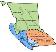
Provincial Groundwater Program Regional Update – West Coast Region
WLRS West Coast Region (WCR) is pleased to provide an update of groundwater-related activities that have been carried out over the year in 2023, with some insight into 2024 operations.
Groundwater Science
New and ongoing groundwater science projects for WCR:
Shawnigan Creek Watershed Model
This past year, the WCR undertook a project to develop an integrated, physically based 3D numerical model of groundwater and surface water flow in the Shawnigan Creek Watershed on Vancouver Island. This watershed has been subjected to heightened stress in recent years due to increased groundwater use and contains many groundwater users that have a strong likelihood of hydraulic connection with streams and/or other users. The WCR developed the numerical model to serve as a decision support tool for conjunctive management of groundwater, surface water, and cumulative effects. At this stage, model development has been completed and the WCR is simulating future scenarios to include in the report that will be published in the Water Science Series.
Comparison of Two Methods for Determining Long-Term Well Yield in British Columbia
Well performance and aquifer capabilities must be assessed to Provincial standards when providing information for groundwater licence applications. Two provincially acceptable methods for evaluating long-term capacities for water supply wells are the 100-day (Ministry of Environment, 1999) and the modified Moell Q20 (Maathuis and van der Kamp, 2006) methods. A comparison and evaluation of these methods was conducted to consider: 1) available drawdown in a well; 2) assessment of where and when these methods apply; 3) prerequisites and assumptions underlying the methods; and 4) other factors that may impact long-term well yield, such as boundary conditions and well interference. A report of the finding has been drafted and will be published on the Water Science Series webpage once finalized.
Groundwater Protection Regulation Compliance
The WCR continues to work closely with the Natural Resource Officers to address compliance concerns received from direct inquiries, and complaints to the Report Natural Resource Violations system (1 877-952-7277). Common groundwater concerns received in the past year included well siting, development impacts to wells and aquifers, dry wells, water use by neighbours, unauthorized groundwater use, and general maintenance requirements.
Saltwater intrusion continues to be a growing concern within the region. Drillers and well pump installers are reminded of their responsibility to be prepared for encountering saltwater during drilling or other operations and knowing what to do if this happens. The Best Practices for Prevention of Saltwater Intrusion and Sea Water Intrusion Advisories can provide information on what to do and at-risk areas. Saltwater intrusion can be costly and difficult to reverse and preventing and mitigating saltwater intrusion will help to keep groundwater resources fresh and support sustainable aquifer management.
The WCR is participating in an ongoing provincial compliance project, targeting well drillers who are not submitting well records within the 90-day requirement. Letters were sent out to all registered well drillers, including a survey to collect information and identify if any training or changes in the submission project are needed or would be helpful. The goals of the project include increasing the GWELLS database with accurate information to be used by well drillers, pump installer, consultants, property owners and others. This information supports provincial efforts for informed decision making on licenses, water budgets, data gaps, emergency response, and aquifer stress.
Authorizations
A provincial initiative began in February 2024, where a centralized existing use groundwater (EUGW) licensing team was established with the primary goal of processing EUGW license applications quickly and efficiently. As of May 1, 2024, approximately 200 EUGW license applications were processed by the centralized team, resulting in many licenses being issued.
As a result, the WCR Water Authorizations Team transferred all but 16 regional EUGW license applications to the centralized team for expedited evaluation. The handful of applications retained by regional staff were either significantly underway or tied to new groundwater use license applications necessitating regional processing.
New use groundwater license applications continue to be processed by the WCR Water Authorizations Team and are prioritized based on ties to housing, agriculture, and time in the water license application queue.
For information on groundwater licensing requirements see Front Counter BC.
Regional Drought Response
Drought response efforts in British Columbia are a shared responsibility that are guided by the British Columbia Drought and Water Scarcity Plan. Within the WCR, numerous streams naturally experience low flow conditions in the summer season. Surface and groundwater use can exacerbate this, and flows can fall low enough which along with rising water temperatures can harm fish and aquatic ecosystems.
In advance of the drought season, the WCR Water Authorizations team hosted or participated in numerous outreach events focussed on drought awareness and response with a look towards the 2024 drought season. These sessions included Decoding Drought Workshops that were hosted by Ministry of Agriculture and Food, a seasonal preparedness workshop that was facilitated by the Ministry of Emergency Management and Climate Readiness (EMCR) and other targeted stakeholder specific presentations.
As the drought season progresses, WCR Water Authorizations and Protection staff will conduct low flow monitoring of fisheries sensitive ecosystems in several east coast Vancouver Island streams (e.g. Koksilah, Tsolum), participate in the Regional Technical Drought Working group and update current conditions via the West Coast Watershed Watch tab, viewable on the BC Drought Information Portal. All readers and other members of the public are encouraged to stay abreast of changing conditions and updated provincial drought levels via the Drought Information Portal link above.
Provincial Groundwater Observation Well Network
The WCR groundwater team expanded by two in March 2024, adding Groundwater Technicians Jennifer Veitch and Harry Tassell. Since starting, the technicians have been working to catch up on the operation and maintenance of more than 80 observation wells in the region. This work includes site visits, data collection and processing, replacing ageing equipment, and upgrading sites to feature telemetry for real-time data availability.
Looking to the future, the added staff capacity will help to maintain high-quality groundwater data for decision makers and expand groundwater monitoring into priority areas. The Provincial Groundwater Observation Well Network is going through a rigorous review period and sites are being checked to ensure they meet the intended monitoring objectives. There may be some changes to monitoring locations as the WCR removes unrepresentative sites to make room for strategic network expansion.

![[picturealttext]](https://news.gov.bc.ca/Content/Images/clear.gif)
WLRS Updates
Source Drinking Water Hazards
WLRS is working with the Ministry of Health and regional Health Authorities to improve knowledge of source drinking water hazards and resilience. Drought (water scarcity) is one of the hazards.
We are developing a Source Drinking Water Risk Assessment Framework to support the multi-barrier approach for understanding and protecting drinking water sources. Accurately identifying where drinking water systems are located and the sources from which they are drawing their water is a fundamental first step for this work.
Much of the data required to inventory all drinking water systems across the Province (i.e., who the drinking water system owners are and where they are located), and then delineate source protection areas around these systems is partially collected by Health Authorities under the Drinking Water Protection Act and WLRS under the Water Sustainability Act, including:
- Water system intake/wellhead information:
- Coordinate location
- License number
- Well tag number
- Water use information
- System size or number of connections
- Water use or pump rate
Access to this data will enable us to create a single authoritative provincial drinking water system spatial dataset.
Drought
Streamflow and groundwater monitoring data along with the snow conditions being reported regularly by the BC River Forecast Centre (RFC) suggest it is possible that the drought conditions experienced across the province in recent years will persist again into this year. Based on these early indications, we recommend all water users prepare for an elevated risk of experiencing drought in 2024.
The Province produces datasets to better understand water availability regionally including:
- Map of 7-Day Average Streamflow displays Water Survey of Canada streamflow gauges in BC.
- The Drought Information Portal displays regional Drought Levels based on indicators.
To translate these regional-scale drought levels to a more local scale understanding of potential water scarcity, the Ministry of Water, Land and Resource Stewardship (WLRS), in partnership with the Regional Health Authorities and the Ministry of Health, will be reaching out directly to drinking water suppliers across the province to collect water supply status information. These surveys will be conducted at regular intervals and will help to understand the state of drinking water supplies throughout the impending 2024 drought season and streamline communication from drinking water suppliers to the provincial government to determine communities at risk of water supply issues and where provincial support is needed.
The Province has several online resources to support water suppliers through drought conditions. The British Columbia Drought and Water Scarcity Plan provides an overview of drought response in the province, including management responsibilities, pre-drought preparedness, descriptions of the provincial drought levels and the potential regulatory actions that may be taken. The Dealing with Drought: Handbook for Water Suppliers provides information to help water suppliers with assessing, planning, and responding to drought conditions and coordinating internal/external communications.

![[picturealttext]](https://news.gov.bc.ca/Content/Images/clear.gif)
Provincial Groundwater Observation Well Network (PGOWN) Update
The Provincial Groundwater Observation Well Network (PGOWN) is happy to announce the completion of its first Operations Manual in many years through the hard work of many ministry staff and the consultants retained for this project. This compilation of guidance material and network standard operating procedures will help to improve data quality and consistency in the operation of the network across the province.
As for the year ahead, the focus will primarily be on contending with ageing network infrastructure. There are projects around the province to decommission and re-drill some older existing observation wells and to replace ageing telemetry equipment at dozens of other stations. It is anticipated that dealing with ageing infrastructure will consume an ever-greater amount of staff time in the years ahead as the PGOWN was established in 1961. The network is showing its age, and this work will help to keep stations functioning properly and generating high-quality data for all interested stakeholders.
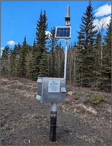
Completed telemetry installation at OW516 in Vanderhoof (2024, ENV).

Do you have questions about the PGOWN?
Contact groundwater@gov.bc.ca
Learn more about the Provincial Groundwater Observation Well Network by using the interactive map.

Registering as a GWELLS user to submit well records online
Get access in three easy steps:
1. Visit the GWELLS BCeID registration page to obtain either a Basic BCeID account or Business BCeID account. (Note, if you already have a Basic or Business BCeID account, you do not need to create a new one to access GWELLS)
2. After obtaining your BCeID, go to GWELLS and select the login button (top right of the application screen).
3. Once you have logged in, email gwells@gov.bc.ca to request access for your BCeID user account.
Once access has been granted, you will be able to enter and submit groundwater well reports through GWELLS.

THIS REPORT IS PREPARED FOR YOU by the water management teams within the Ministry of Water, Land, and Resource Stewardship (WLRS), and the Ministry of Environment and Climate Change Strategy (ENV)

![[picturealttext]](https://news.gov.bc.ca/Content/Images/clear.gif)
CONTACT US
For general inquiries or the contact information for groundwater staff with statutory designation across the province, contact Groundwater@gov.bc.ca


