Resources
B.C. Groundwater Updates
Edition: Update on Groundwater, June 2025

IN THE JUNE 2025 ISSUE:
- WLRS Updates
- Provincial Government Groundwater Program Regional Update
- Provincial Groundwater Observation Well Network (PGOWN) Update
- Registering as a GWELLS user to submit well records online
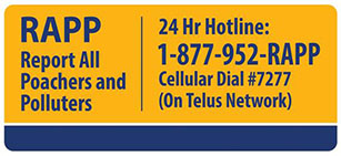
REPORT NON-COMPLIANCE
- Have you noticed a well that does not meet the construction standards of the Groundwater Protection Regulation?
- Know of someone who is drilling a well or installing a well pump without being registered?
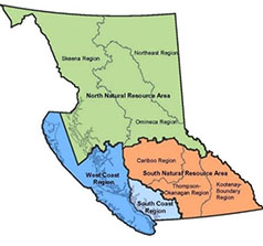
Provincial Groundwater Program Regional Update – West Coast Natural Resource Area
WLRS West Coast Region (WCR) is pleased to provide an update of groundwater-related activities that have been carried out over the past year and some updates for future operations.
Groundwater Science
New and ongoing groundwater science projects for WCR:
French Creek Hydraulic Connection and Aquifer Mapping Study
This study involved developing a three-dimensional (3D) hydrogeological conceptual model of the Nanaimo Lowlands region from Englishman River to Deep Bay that built on previous work to refine the geometry of aquifers in the region, update bedrock topography and delineate groundwater elevations for both bedrock and overburden systems. The revised 3D model provided a framework for interpreting potential hydraulic connectivity between streams and aquifers in the region. Five new unconsolidated aquifers and one new bedrock aquifer were mapped and classified. The boundaries of eleven existing aquifers were modified, and the boundaries of two existing aquifers remained unchanged. Aquifer classification reports were prepared or revised and included well-aquifer correlations, model interpretations, local knowledge and classification criteria. Provincial observation wells were reassigned to mapped aquifers based on water level characteristics, completion details and water chemistry. A GIS-based analysis of stream-aquifer hydraulic connection was completed using modelled aquifer bottom and top surfaces, streambed elevations and interpolated groundwater elevation in the bedrock and unconsolidated formations. The results show streams discretized into segments and classified as: a) disconnected, b) hydraulically connected - gaining, or c) hydraulically connected - losing or perched. Stream profiles were prepared which show the hydrostratigraphic units within a cross-sectional area underlying major streams. The report can be found in the Water Science Series.Tsolum River Fiber Optic Distributed Temperature Sensing Pilot Project, Comox
In August 2024, a pilot project was initiated on the Tsolum River to trial fiber optic distributed temperature sensing (FO-DTS) technology with the aim of collecting high temporal and spatial resolution temperature data to support water management decisions on the Tsolum River and inform when and how the technology might benefit water management science across the province. The project is being led by staff in the Watershed Stewardship and Security Branch of the Ministry of Water, Land, and Resource Stewardship (WLRS), partnered with K’ómoks First Nation (KFN) and supported by the Tsolum River Restoration Society, Centre of Transformative Environmental Monitoring Programs, Department of Fisheries and Oceans Canada, the Pacific Salmon Foundation, and WLRS’ WCR Authorizations Branch.
Year one of this two-year project involved deploying 1,750 metres (m) of fiber optic cable along the streambed of the Tsolum River from August to October 2024 to monitor water temperatures every 0.25 m during the transition from low flow to the start of the fall rainy period. Preliminary results for the first year identify three locations where colder groundwater is discharging into the Tsolum River. These areas are likely critical for providing cold-water refugia for salmon and could highlight priority areas for reclamation and enhancement work. Data and results from this study are hoped to support co-management decisions on restoration, habitat enhancement, and recovering Tsolum River salmon populations as well as characterize groundwater-surface water interactions to support decisions on drought and licensing.
B.C. Groundwater Protection Regulation Compliance
The WCR continues to work closely with the Natural Resource Officers to address compliance concerns received from direct inquiries, and complaints to the Report Natural Resource Violations system (1 877-952-7277). Common groundwater concerns received in the past year included well drilling, impacts from development, well siting, dry wells, artesian flowing wells, seawater intrusion, quantity and quality issues, neighbouring water use, unauthorized groundwater use, and general maintenance issues.
Seawater Intrusion
Seawater intrusion continues to be a growing concern within the region, and cases brought to our attention continue to increase. Drillers and well pump installers are reminded of their responsibility to be prepared for encountering seawater or saline groundwater during drilling or other operations and knowing what to do if this happens. The Best Practices for Prevention of Saltwater Intrusion and Sea Water Intrusion Advisories can provide information on what to do and at-risk areas. Seawater intrusion can be costly and difficult to reverse and preventing and mitigating seawater intrusion will help to keep groundwater resources fresh and support sustainable aquifer management.
Flowing Artesian Wells
Flowing artesian wells are another complicated and common compliance issue in the WCR. A flowing artesian well must be under control, which means that the flow:
- Must be conveyed through the well’s production casing;
- Can be stopped indefinitely without leakage outside of the production casing; and
- Must not pose a threat to property, public safety or the environment.
If flowing artesian conditions are encountered during construction or are suspected to occur at some point during operation, the well driller must stop the flow or bring the well under control. If flowing artesian conditions start after the well is constructed and are not suspected during construction, the well owner must retain a registered well driller or professional to put the well under control. Flowing artesian wells can pose a risk to safety, environment and property and can have an impact on groundwater levels within an aquifer.
There is currently one flowing artesian advisory for the WCR, for Quadra Island and wells that are noted to have encountered artesian conditions during drilling are identified in the GWELLS maps. Artesian conditions exist in other areas of the WCR and care and due diligence must be taken to prepare for possible artesian conditions encountered during or after well construction.
Drill Record Compliance
The WCR, along with other regions, is considering the most effective and efficient approach to address well record submission non-compliance, particularly from repeat offenders. This is in follow-up to the provincial well record submission project, which identified non-compliance and made significant updates to the GWELLS registry. Well Records are required to be submitted for well construction, alteration and decommissions within 90 days of completion. This information supports provincial efforts for informed decision making on licenses, water budgets, data gaps, emergency response, and aquifer stress.
Authorizations
A provincial initiative began in February 2024, where a centralized existing use groundwater (EUGW) licensing team was established with the primary goal of processing EUGW license applications quickly and efficiently. As of May 2025, approximately 630 EUGW license applications were processed by the centralized team, resulting in many licenses being issued. Regionally, approximately 135 of these processed applications were within the WCR.
New use groundwater license applications continue to be processed by the WCR Water Authorizations Team and are prioritized based on ties to provincial priorities identified by the government, including public safety and housing, as well as time in the water license application queue. For information on groundwater licensing requirements see Front Counter BC.
Regional Drought Response
Drought response efforts in BC are a shared responsibility that are guided by the BC Drought and Water Scarcity Response Plan. A new version of the BC Drought and Water Scarcity Plan was released in May 2025 that updates the criteria for setting drought levels and establishes drought levels as an objective measure of drought hazard. Drought levels now provide a snapshot of drought conditions at a point in time and measure the severity of dryness relative to the historical record. In this new approach they no longer reflect the consideration of impacts. The Water Management Branch is responsible for recommending and formalizing drought levels, viewable on the BC Drought Information Portal. Local drought monitoring led by regional teams will be focused on monitoring localized conditions and reporting of impacts as drought conditions worsen.
Within the WCR, numerous streams naturally experience low flow conditions in the summer season. Surface and groundwater use can exacerbate this, and flows can fall low enough, which along with rising water temperatures, can harm fish and aquatic ecosystems. In advance of the drought season, the WCR Water Management team hosted or participated in outreach events focused on drought awareness and response with a look towards the 2025 drought season. These sessions included a virtual Decoding Drought Workshop hosted by Ministry of Agriculture and Food, a seasonal preparedness workshop facilitated by the Ministry of Emergency Management and Climate Readiness (EMCR) and other targeted stakeholder specific presentations. As the drought season progresses, WCR Water Management staff will conduct low flow monitoring of fisheries sensitive ecosystems in several east coast Vancouver Island streams (e.g. Koksilah and Tsolum rivers), participate in the Regional Technical Drought Working Group (RTDWG) and update the Provincial Technical Drought Working Group (PTDWG) about local impacts and conditions. All readers and other members of the public are encouraged to stay abreast of changing conditions and updated provincial drought levels via the Drought Information Portal link above.
Provincial Groundwater Observation Well Network
With seawater intrusion becoming more of a focus on the coast, the two WCR technicians have been gathering and creating conductivity profiles of all observation wells located on Cormorant, Quadra, Denman, Hornby, Gabriola, Salt Spring, Saturna, Galiano, Mayne and Pender Islands. Along with the profiles, three conductivity loggers have been purchased for the network. They have already been deployed on Denman (OW#266) and (Hornby (OW#288), and the third will be deployed on Galiano (OW#321) in May. These sensors will provide valuable information on seasonal water quality trends in these wells.
A new observation well was drilled and completed in the Comox Valley to monitor aquifer #408, although the resulting lithology did not show the expected quadra sands formation. The well is currently being monitored and will be brought into the network over the coming months. There has been ongoing work towards getting a new well drilled on Cormorant Island to eventually replace the current observation well located in Alert Bay (OW#201). The work is expected to be completed by the end of 2025.
The WCR team has gathered exciting momentum for the year ahead and are optimistic to tackle upcoming goals.
![[picturealttext]](https://news.gov.bc.ca/Content/Images/clear.gif)
WLRS Updates
Drought
Prepare for drought again this year
Already for this year, we see low snowpack and low seasonal runoff forecasts reported by the BC River Forecast Centre (RFC), combined with warm seasonal weather forecasts and lingering effects from ongoing drought point to elevated drought hazards for this spring and summer. We recommend all water users prepare for an elevated risk of drought in 2025 and stay informed about drought conditions in your area as the season progresses.
The Drought Information Portal is a single source to access drought levels across geographic regions in BC. The maps provide information on current and historical provincial drought levels and other information related to drought monitoring.
Updates to drought monitoring
In 2025, the criteria for setting drought levels have been updated to establish drought levels as an objective measure of drought severity relative to the historical record, while still maintaining the six-level rating scale.
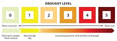
B.C.’s drought level scale for drought conditions. The severity of dryness increases from Level 0 (no drought) to Level 5 (highest severity of drought) along a six-level scale which also represents how often a given level of dryness may naturally reoccur.
Drought levels were previously used as a single measure to represent a range of information including physical conditions, observed impacts, and forecasts. This could make it difficult to interpret the meaning of a drought level from week or week or basin to basin, and to establish a reliable historical record of actual drought conditions. As of 2025, drought levels now provide a snapshot of drought conditions at a point in time and no longer reflect the consideration of impacts or the need for management action, which also depend on the exposure and vulnerability of different values and assets to drought conditions.
Drought conditions are primarily set based on a convergence of evidence from a suite of hydrometeorological drought indicator data gathered from automated climate and hydrometric stations across the province. Daily groundwater levels are now a main drought indicator and over 200 observation wells within the Provincial Groundwater Observation Network are used to assess drought conditions across the province.
Separating drought conditions from drought impacts is a first step towards structuring the information we collect on both conditions and impacts to better support local risk assessments and local management actions. The B.C. government will continue to actively map and share information on local impacts and risk where available, through the B.C. Drought Information Portal.
Annual Water Supply Status Survey in progress again
To better find out about regional-scale drought impacts on communities during times of water scarcity, the Ministry of Water, Land and Resource Stewardship, in partnership with the Regional Health Authorities, Indigenous Services Canada and the BC Water & Waste Association, is surveying drinking water suppliers directly across the province to collect information about water supply. Invitations to fill out the survey will be sent at regular intervals to local government, improvement districts, utilities, and First Nations water suppliers, and posted to the BC Small Water Systems Community Network. The survey responses will help to understand the state of drinking water supplies throughout the 2025 drought season and streamline communication from drinking water suppliers to the provincial government to better understand which communities are at risk of water supply issues and where provincial support may be needed.Resources to prepare for drought available
The B.C. government has several online resources to support water suppliers through drought conditions. Two key resources:
- The BC Drought and Water Scarcity Response Plan provides an overview of drought response in the province, including management responsibilities, pre-drought preparedness, drought monitoring components, and possible drought response actions. You can also find more information in the plan on the changes to drought monitoring for 2025.
- The Dealing with Drought: Handbook for Water Suppliers will be updated in 2025 and sets out information to help water suppliers with assessing, planning, and responding to drought conditions and coordinating internal/external communications.
“Groundwater, Well and Aquifers in BC” Story Map
The Aquifer and Watershed Science team has been working on improving the information available through the provincial groundwater webpages. As part of this work, a story map was created to provide the general public with an introduction to groundwater science. Check out the “Groundwater, Well and Aquifers in BC” story map to learn more about the groundwater concepts that are most relevant in B.C.!
In addition, general clean-up of the Provincial groundwater webpages is underway, so you may notice some change to the web content over the coming months. We are making every effort to upgrade the flow and content of the webpages, as seamlessly as possible, however if you come across any broken links, please reach out GroundWater@gov.bc.ca to let us know.
Provincial Groundwater Observation Well Network (PGOWN) Update
The primary objective of PGOWN is to collect high-quality long-term groundwater level data to support the management, protection and sustainable use of our groundwater resources and associated ecosystems. Monitoring typically occurs in aquifers of importance to the surrounding community due to their reliance on this resource for agricultural and domestic uses, amongst others.
As part of this objective, the long-term trends in groundwater level data are analyzed every 5 years by Environmental Reporting BC within the Ministry of Environment and Parks. The most recent analysis was published earlier this year and includes an interactive map and accompanying PDF report. To review the complete report and the methodology behind it, or to download the available R package and run an updated analysis at any time, please visit the Long-Term Trends in Groundwater Levels in B.C. website.
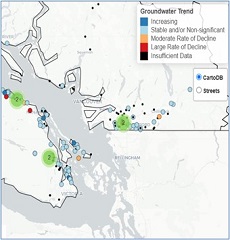
Groundwater level trends map (Environmental Reporting BC, 2025).
In comparison to previous trend reports, this iteration included more stringent data requirements (meaning some additional wells were excluded from analysis) and also allowed for different trend timespans to be analyzed, such as 10, 20 or all available data timespans, as well as seasonal versus annual trends in groundwater levels. For example, out of the 113 aquifers that were analyzed for 10-year groundwater level trends (via 140 PGOWN wells), at least 8% demonstrated some rate of decline; an additional 7% of aquifers demonstrated ‘mixed’ trends where different observation wells exhibited different trends within the same given aquifer (typically in bedrock aquifers which are known for being highly heterogeneous). However, please refer to the actual report in the link above for complete results.
Do you have questions about the PGOWN?
Contact groundwater@gov.bc.ca
Learn more about the Provincial Groundwater Observation Well Network by using the interactive map.
Registering as a GWELLS user to submit well records online
Get access in three easy steps:
1. Visit the GWELLS BCeID registration page to obtain either a Basic BCeID account or Business BCeID account. (Note, if you already have a Basic or Business BCeID account, you do not need to create a new one to access GWELLS)
2. After obtaining your BCeID, go to GWELLS and select the login button (top right of the application screen).
3. Once you have logged in, email gwells@gov.bc.ca to request access for your BCeID user account.
Once access has been granted, you will be able to enter and submit groundwater well reports through GWELLS.
THIS REPORT IS PREPARED FOR YOU
by the water management teams within the Ministry of Water, Land, and Resource Stewardship (WLRS), and the Ministry of Environment and Parks (ENV).
Contact Us


