Resources
B.C. Groundwater Updates
Edition: Update on Groundwater, March 2025

IN THE March 2025 ISSUE:
- GWELLS-2024 Review of Well Record Submissions
- WLRS Updates
- Provincial Government Groundwater Program Regional Update
- Provincial Groundwater Observation Well Network (PGOWN) Update
- Registering as a GWELLS user to submit well records online
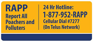
REPORT NON-COMPLIANCE
- Have you noticed a well that does not meet the construction standards of the Groundwater Protection Regulation?
- Know of someone who is drilling a well or installing a well pump without being registered?
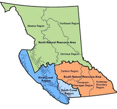
Provincial Groundwater Program Regional Update – South Coast Natural Resource Area
Groundwater Protection Regulation (GWPR) Compliance
During the past year, the South Coast Groundwater Team received more than 40 GWPR related inquiries, complaints and compliance files, including multiple cases of flowing artesian wells and potential saltwater intrusion. Staff continue to provide timely responses to complaints and enquiries related to groundwater and wells. The Natural Resource Violation Line (NRV) is the best way to report a violation of the GWPR or Water Sustainability Act, and reports can be submitted anonymously. For more information visit the NRV website or call 1-877-952-7277 Option 2.
In 2024, Groundwater Protection Officer, Kumar KC supported a provincial Well Record Submission Project. The project aimed to increase compliance with GWPR Section 76 requirement for well records to be submitted within 90-days of well completion. The project comprised of a mailout package sent to all registered drillers within the province informing them of the regulatory requirements and requesting outstanding well completion reports be submitted by a deadline.
The Province of BC has issued a new Sea Water Intrusion Advisory for Richmond and Delta. Many parts of these cities are predicted to be at higher risk of Sea Water Intrusion due to the proximity to ocean and tidally affected river, low elevation, and shallow permeable sediments. The new advisory is applicable to anyone construction and operating a well or dewatering an excavation in this area.
Drought Response and Water Allocation
In early 2024, our focus was on preparing for another potentially severe drought season. Low snowpacks and low groundwater levels generated poor drought forecasts through the winter. However, a wet spring turned the conditions in a positive direction, delaying the onset and reducing the overall severity of the drought in the South Coast Region. Our groundwater and surface water allocation teams worked with partner agencies to respond to the drought. Efforts focussed on outreach, education, communication and partnership resulted in our most collaborative drought response yet!
Due to the high number of unauthorized water users, the South Coast’s drought response continues to focus on addressing unauthorized water use, rather than curtailing authorized water users. In 2024, we targeted key watersheds with strategic efforts to increase compliance with the Water Sustainability Act. We issued a total of 1229 advisory letters and warning letters, held 11 outreach events, conducted door-to-door property visits, and issued 11 stop use orders. We also issued 1506 drought letters requesting voluntary reduction from applicants and licensees across the region.
As compliance actions have resulted in increased water license applications, we are turning our attention to managing and allocating water resources in our target watersheds. In 2025, our authorizations team is conducting a pilot project to develop innovative approaches to managing water use in complex watersheds with a high user density and increasing water scarcity.
In addition to this pilot project, the groundwater authorizations team continues to have many applications in the queue. Applications are generally prioritized by date of submission. However, under the Provincial Housing Strategy priority is given to some housing related files. Both Provincial and Regional efforts are being made to work on licence applications and to streamline the processes.
The first Water Allocation Notations were added to aquifers in the South Coast Region, including Possible Water Shortage notations on Aquifer 33 and Aquifer 1144.
Groundwater Studies
The Provincial Groundwater Science Program has kindly provided funding for several projects:
- Environmental Flow Needs Methodology for Tidally Influenced and Low Flow Streams: This multi-year project is being conducted at Simon Fraser University (SFU). It includes a MIKE-SHE groundwater model for the lower Fraser Valley and detailed stream characterization.
- The Aquifer Remapping and Well Correlation in Bertrand Creek, Fishtrap Creek and Little Campbell River project is in it’s second year.
- Two new publications on the Water Science Series:
We are also partnered with SFU and the Pacific Institute of Climate Solutions (PICS) on a multi-year project titled “Drought and deluge: informed water allocation decision making in a world of intensifying hydrologic extremes”. In 2024, a research publication titled Groundwater Responses to Deluge and Drought in the Fraser Valley, Pacific Northwest (open source) was published under the project.
South Coast Provincial Groundwater Observation Network (PGOWN)
In 2024, our Groundwater Technician, Lindsay Eenkooren, dedicated significant efforts to assessing the condition of the South Coast PGOWN Network and conducting required repairs and upgrades. Along with upgrading and replacing aging equipment, she conducted downhole camera inspections at every observation well. These inspections will support annual comprehensive infrastructure reviews, which were introduced under the new PGOWN Operations Manual and Standard Operating Procedures (ENV, 2025). This new guidance represents a significant achievement in the advancement of the PGOWN program, as it includes Standard Operating Procedures designed to standardize data collection across all regions, ensuring consistency and quality.
A few notable modifications were made to the South Coast Network in 2024. A new telemetry station was successfully installed on Savary Island (OW511). Real-time data from this station is now available in the public database. After careful consideration, two redundant monitoring wells, OW259 and OW359, were removed from the network and are replaced by OW491 and OW415 respectively.
Two Groundwater Monitoring Specialists, Graeme Henderson and Caroline Wisheart, now support the Groundwater Technician with operation of the South Coast PGOWN network. The team has gathered exciting momentum and are optimistic about tackling upcoming goals for 2025.
Real-Time Water Data https://www2.gov.bc.ca/gov/content/environment/air-land-water/water/water-science-data/water-data-tools/real-time-water-data-reporting
EcoCat
THIS REPORT IS PREPARED FOR YOU by the water management teams within the Ministry of Water, Land, and Resource Stewardship (WLRS), and the Ministry of Environment and Parks (ENV)

WLRS Updates
What is the difference drilling versus excavating monitoring wells and geotechnical wells?
In general, the construction, decommissioning and other well related activities require a qualified well driller or that the person is under the direct supervision of a well driller or professional in the field of hydrogeology or geotechnical engineering to perform that restricted activity (WSA S.49(2)).
A few exemptions to these requirements are detailed under WSA S.49(3) including a person excavating a well to a depth of not more than 15m (excavated well is defined in GWPR S.1), or a person constructing or decommissioning a geotechnical well if not likely to penetrate an aquifer. WSA s. 49(4) states that if an aquifer is penetrated whilst constructing a geotechnical well, they must stop and a qualified person must take over.
Despite the exemptions in the above scenarios, a driller or professional is required for excavating/drilling in monitoring well and geotechnical scenarios and they must have competency in stopping or controlling artesian flow (WSA S.52(2)and (3)) if there are artesian conditions (information on GWELLS and the Flowing Artesian Advisory Webpage).
The Province published a Groundwater Protection Regulation: Guidance Manual that provides information on the various provisions regulating groundwater protection in British Columbia. Additionally, the BCGWA handbook is a plain language document that contains a helpful overview. Please refer to Tables 2 and 3 that outlines requirements for persons authorized to construct a geotechnical and monitoring well respectively. Users of these manuals should refer directly to the WSA and GWPR prior to taking action(s) to make sure they are consulting the most current version of applicable laws. Where contents differ, the provisions in the WSA and GWPR take precedence over the guidance in these manuals or other materials (including this condensed article).
3rd Annual BC Groundwater Symposium
On December 12th, 2024, the Aquifer and Watershed Science team, within WLRS hosted the 3rd annual BC Groundwater Science Symposium. The online event, featuring a series of short presentations highlighting current provincial groundwater research and monitoring projects, was attended by nearly 350 attendees from right across the country. Attendees included BC First Nations, Federal government, Provincial governments from across Canada, universities, municipalities, consultants, mining companies, water suppliers/haulers, drillers and well pump installers, NGOs, and citizen science organizations. The majority of the presentations were based on research summaries compiled in the Compendium of Provincial Groundwater Science and Monitoring Projects: 2023/24, available on the government Water Science Series webpage. Many thanks to the presenters and to all those who attended the day of learning and knowledge transfer. See you next year!
![[picturealttext]](https://news.gov.bc.ca/Content/Images/clear.gif)
Provincial Groundwater Observation Well Network (PGOWN) Update
PGOWN has been collecting data on groundwater levels for over 60 years. In recent years, there have been attempts to use this to help inform drought monitoring, primarily by evaluating groundwater level percentiles for stations with sufficient data.
More recently, ENV together with the River Forecast Centre (RFC) have been working towards operationalizing research from Simon Fraser University (SFU) to forecast the potential for groundwater drought by using data from the PGOWN and other monitoring station types. This is the second year of that project, and it is expected to be completed in the months ahead. Ideally this work will result in a map, updated daily, to forecast the probability of groundwater drought weeks in advance.
This information could then help inform water managers and other stakeholders to make more proactive decisions. It is anticipated that all reports and online mapping tools will be publicly available once they have been completed and approved. Previously published research from SFU on this topic can be found by checking the Water Science Series published by WLRS.
To see current groundwater level percentiles and regional drought reports produced based on PGOWN data, please visit the BC Drought Information Portal.
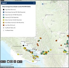
Groundwater conditions map from the BC Drought Information Portal (2025, RFC).
Do you have questions about the PGOWN?
Contact groundwater@gov.bc.ca
Learn more about the Provincial Groundwater Observation Well Network by using the interactive map.
Registering as a GWELLS user to submit well records online
Get access in three easy steps:
1. Visit the GWELLS BCeID registration page to obtain either a Basic BCeID account or Business BCeID account. (Note, if you already have a Basic or Business BCeID account, you do not need to create a new one to access GWELLS)
2. After obtaining your BCeID, go to GWELLS and select the login button (top right of the application screen).
3. Once you have logged in, email gwells@gov.bc.ca to request access for your BCeID user account.
Once access has been granted, you will be able to enter and submit groundwater well reports through GWELLS.


