Resources
B.C. Groundwater Updates
Edition: Update on Groundwater, September 2024

IN THE SEPTEMBER 2024 ISSUE:
- WLRS Updates
- Provincial Government Groundwater Program Regional Update
- Provincial Groundwater Observation Well Network (PGOWN) Update
- Registering as a GWELLS user to submit well records online
REPORT NON-COMPLIANCE
- Have you noticed a well that does not meet the construction standards of the Groundwater Protection Regulation?
- Know of someone who is drilling a well or installing a well pump without being registered?


Provincial Groundwater Program Regional Update – South Natural Resource Area
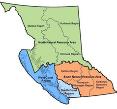
The year 2024 has been an active year for the South Area Groundwater Science Team. We are pleased to provide an update on groundwater activities being carried out by the groundwater staff in the South Natural Resource Area of the Ministry of Water, Land and Resource Stewardship (WLRS). The South Area includes the Cariboo, Thompson-Okanagan, and Kootenay-Boundary Regions.
Groundwater Science
Drought Support
South Area Groundwater Science continues to support the Provincial drought response through a variety of site and watershed-scale activities. These drought coordination activities are currently focused within the Kootenay-Boundary and the Thompson-Okanagan Regions to inform the application of regulatory tools for managing water use in times of scarcity.
Earlier this year, ‘Decoding Drought’ sessions were held in-person throughout the Okanagan and Kootenays. These public information sessions were conducted with Ministry of Agriculture and Water Resources staff to provide drought information to agricultural producers, irrigators, small water system providers, and interested public. Attendees received information on the science available and decision tools used for setting provincial hydrological drought levels. Information on resources available to agricultural producers was also provided. These sessions provided an opportunity for the public to voice their concerns and engage directly with provincial staff. Feedback from these sessions was incorporated in drought management planning for the 2024 season.
Aquifer Mapping Updates in Kootenay-Boundary Region
New and updated aquifer mapping information is available for the Creston, Rossland, Castlegar and Salmo areas. Twenty-three (23) aquifers were mapped within the study area. The aquifer mapping report is available as a 2024 Water Science Series publication.
Assessment of Groundwater – Surface Water Interactions on the Vaseux Creek Alluvial Fan, Oliver, BC
snʕax̌əlqaxʷiyaʔ (Vaseux Creek) is a site of regular water scarcity-based conflict related to flow requirements for culturally significant fish species, human water use demands, and the current hydrological system. In partnership with the Okanagan Nation Alliance (ONA), this ongoing three-year research project focuses on groundwater/stream interactions across an alluvial fan within the traditional lands of the Osoyoos Indian Band (OIB). Analysis will inform an increased understanding of the dynamics between groundwater and surface water to support effective water management on this site. See the Compendium of Provincial Groundwater Science and Monitoring Projects for more information on this Water Science Series project and others.
Updated Water Budget for Salmon River Valley Aquifers Upstream of Falkland
Published in June 2024 by the Water Science Series, the report builds on past studies within the watershed with a focus on quantifying key water budget components useful to informing management decisions.
Groundwater Monitoring – South Area
The Provincial Groundwater Observation Well Network (PGOWN) is currently comprised of 240 active observation wells, 75 of which are located within South Area. The PGOWN wells monitor groundwater levels using pressure transducers that collect data hourly. PGOWN groundwater level data may be viewed on the interactive map platforms: Groundwater Level Data Interactive Map or Real-time Water Data WebPortal.
Nearly two-thirds of the observation wells in the PGOWN transmit real-time data via satellite telemetry. Upgrades to telemetry equipment in South Area ensure more reliable access to water level data. Upgrades are ongoing, with several wells in the Thompson-Okanagan Region already receiving upgraded equipment: two at Falkland, one in Merritt, one in Osoyoos, and two in Oliver.
Drilling of a replacement for existing PGOWN observation well 045 in the Westwold Valley is proposed for quarter 3 (Q3) of 2024. The current well 045 cannot accept telemetry installation and must be visited every time that data is downloaded. The replacement well will permit the installation of satellite telemetry to provide real-time hourly water level data. The South Area network is operated by one full-time, dedicated Groundwater Technician and one part-time Groundwater Technician.
Well completion reports are available from the EcoCat Ecological Reports Catalog for the following South Area PGOWN wells: Spotted Lake (aquifer 0238 – OW512); Canyon area of Creston (aquifer 0489 – OW509); Tulameen (aquifer 1010 – OW508); Deep Creek (aquifer 1153 – OW510); and Salmon River near Falkland (aquifer 0097 – OW514 and OW515).
Groundwater Protection and Regulatory Compliance
South Area staff continue to provide timely responses to complaints and enquiries related to groundwater and wells. Problems with well construction and poor maintenance, improper well siting, uncontrolled flowing artesian conditions, work completed by under qualified or non-registered practitioners and failure to submit well construction records are just some of the issues groundwater protection officers have responded to. Ministry staff continue to work with industry professionals and collaborate with Interior Health staff on Groundwater-related issues requiring a multi-jurisdictional assessment.
Groundwater Protection Officer (GPO) Laura Maclaren participated along with other key provincial GPOs in the Well Report Submission Project. The project aimed to increase compliance with the Groundwater Protection Regulation (GPR) Section 76 requirement for well records to be submitted within 90-days of well completion. The project was initiated on February 1, 2024, and was comprised of a mailout package sent to all registered drillers within the province informing them of the regulatory requirements and requesting outstanding well completion reports be submitted by May 29, 2024. The mailout package also included a survey for water well drillers to provide feedback on their experience with the online system and an opportunity to update contact information for the Registry.
Staffing Changes
Regional Hydrogeologist David Thomson is enjoying a six-month sabbatical, returning in November 2024. Laura Maclaren joined our team in Fall 2023 as the Groundwater Protection Officer based at the Penticton office. Regional Hydrogeologist, Stephanie Drake joined the South Area team in early 2024 and works from our Kamloops office. Stephanie draws on many years of experience from consulting to provide hydrogeological support to the pubic and water staff in the South Okanagan and Kootenay-Boundary regions.

THIS REPORT IS PREPARED FOR YOU by the water management teams within the Ministry of Water, Land, and Resource Stewardship (WLRS), and the Ministry of Environment and Climate Change Strategy (ENV)

WLRS Updates
To improve the province’s understanding of the impact of drought on drinking water supply, the Ministry of Water, Land and Resource Stewardship (WLRS), in partnership with the Regional Health Authorities and the Ministry of Health, has distributed water supply status surveys to 445 local governments, improvement districts and private utilities. WLRS has also worked in partnership with Indigenous Services Canada to distribute the survey to 180 First Nations water suppliers. These surveys have been sent on a bi-weekly basis since late May 2024 to capture changing water supply conditions throughout the drought season. The response rate is increasing over time and the overall effectiveness of this process will be evaluated in the post-drought season.
The Drought Information Portal is a single source platform that provides geographic drought level information for people in British Columbia. The Drought and Watershed Watch Map uses multiple embedded maps to provide information on drought levels, watershed conditions and drought monitoring data including active groundwater observation wells providing daily groundwater level conditions and other water monitoring data. Regional groundwater level condition and low streamflow reports can be found by visiting the links listed in the regional description panels on the Drought and Watershed Watch Map.
The province has several online resources to support water suppliers through drought conditions. The British Columbia Drought and Water Scarcity Response Plan provides an overview of drought response in the province, including management responsibilities, pre-drought preparedness, descriptions of the provincial drought levels and the potential regulatory actions that may be taken. The Dealing with Drought: Handbook for Water Suppliers provides information to help water suppliers with assessing, planning, and responding to drought conditions and coordinating internal/external communications.
The Watershed Stewardship and Security Branch, in collaboration with Water Management Brach, recently published a spatial dataset on Water Sustainability Temporary Protection Orders (TPOs). TPOs are ministerial orders implemented in times of water scarcity and/or drought to protect streamflow availability. TPOs were implemented under Section 9 of the Fish Protection Act prior to 2016, but are now implemented under Section 86, 87 and 88 of the Water Sustainability Act. The purpose of the dataset is to communicate to both surface and groundwater users when and where TPOs are/were in effect. This TPOs layer is now viewable in iMapBC and will be added to the Draught Information Portal in the near future.
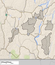
Example of “Temporary Protection Orders - Historical” layer in iMapBC
A new Best Practices for Groundwater Wells Going Dry and Drought Preparation brochure is available to provide well owners information on why their well may go dry and describes best practices for managing wells in times of scarcity. Copies of the brochure can be obtained from your local Ministry staff.

Provincial Groundwater Observation Well Network (PGOWN) Update
The PGOWN is continuing to advance projects to improve data quality and utility. This includes commencing a multi-year project to survey stations and publish elevation data sets relative to a common datum (sea level). As the network consists of 240 stations, this project will be phased in over the next few years. This year, it is anticipated that approximately 40 to 50 wells will be surveyed. Their datasets will be published later in the year and updated daily for telemetry stations.
In addition, groundwater level data processing and QA/QC procedures are being updated to ensure the network continues to produce high-quality, reliable data, and historical data is also being more thoroughly reviewed and corrected where necessary (note: the review of historical data will take some time to complete). This data quality improvement work includes replacement of ageing equipment and wells, as discussed in previous BCGWA newsletters, as well as how data itself is processed in our system.
Lastly, an update to the long-term trend analysis of groundwater levels will soon be published by Environmental Reporting BC. This updated trend analysis has been improved upon since the last report in 2019, such as allowing for the selection of 10-year, 20-year and entire-period-of-record trend analysis options.

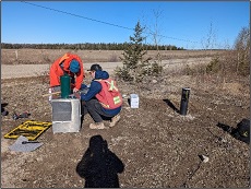
Building of telemetry station at OW517 in Vanderhoof (2024, ENV).

Do you have questions about the PGOWN?
Contact Groundwater@gov.bc.ca
Learn more about the Provincial Groundwater Observation Well Network by using the interactive map.

Registering as a GWELLS user to submit well records online
Get access in three easy steps:
1. Visit the GWELLS BCeID registration page to obtain either a Basic BCeID account or Business BCeID account. (Note, if you already have a Basic or Business BCeID account, you do not need to create a new one to access GWELLS)
2. After obtaining your BCeID, go to GWELLS and select the login button (top right of the application screen).
3. Once you have logged in, email gwells@gov.bc.ca to request access for your BCeID user account.
Once access has been granted, you will be able to enter and submit groundwater well reports through GWELLS.

CONTACT US
For general inquiries or the contact information for groundwater staff with statutory designation across the province, contact Groundwater@gov.bc.ca


